|
Reading ChartTiff NxGen Geos / Geos and ChartTiff USGS DOQQs / NAIP DOQQs
and ChartTIff NEDs / DEMs into PLS-CADD
ChartTiff offers Collarless / Seamless Topo Maps for PLS-CADD.
ChartTiff offers Elevation Data in PLS-CADD XYZ File Format.
Users can now do simple File / Open to input Elevation Data.
Once Elevation Data is in cart, simply check out and
select PLS-CADD XYZ File Format as the Output Format.
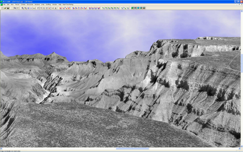
PLS-CADD 3D Image using ChartTiff 30 Meter NEDs and DOQQs
of the Grand Canyon, AZ
Importing ChartTiff Geos / DRGs / DOQQs and NEDs / DEMs into PLS-CADD
Power Line Systems has developed a Tech Note describing the how in import
ChartTiff Geo's / DRGs / DOQQs and NEDs / DEMs into PLS-CADD.
Click here to go to PLS-CADD TechNote
Watch You Tube Video
The following is a quote from the Tech Note:
"Since this TechNote was first developed in the summer of 2000, the USGS has undergone many changes in their data formats and sources. As a consequence, they made previous conversion programs obsolete and more difficult to use in practice. For these reasons, we now recommend that you obtain your USGS data in a readily used format at a minimal cost from ChartTiff. The rest of this TechNote will explain how to use ChartTiff's data, as it is much easier to use. The folks at ChartTiff have been a big help to us and have even provided a download format that essentially imports directly into PLS-CADD. We would highly recommend that you support them and if they ask, please tell them that Power Line Systems recommended them. At the price of $3 per quad sheet for both a collarless DRG and a full NED/DEM, ready to be imported into PLS-CADD and available in the coordinate system of your choice, this is a no-brainer."
|

